
Phase I (1554-55) - Rua Nova da Palma
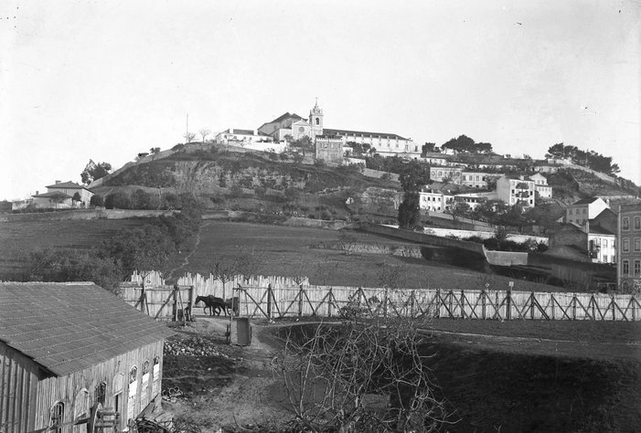
The medieval city limits
Defined in this area by the Cerca Fernandina (1373-75), the urban defensive wall that crossed the southern third of what is now Praça do Martim Moniz, it did not allow for an efficient flow of traffic into and out of the city. In the 16th century, the main axis of circulation was at the junction of Porta de São Vicente, Rua da Mouraria and extended northwards by Rua do Benformoso and Rua Direita dos Anjos.
Widening of Rua Nova da Palma
The urban planning initiative of the canons of São Vicente de Fora, which led to the opening of a new wicket and the creation of Rua Nova da Palma (later widened in 1776) on the grounds of their vegetable gardens, combined with the opportunity for new allotments and the need for an alternative way in and out of this busy area of the city, is at the origin of the regularization of the road axis that would come to carve out the northern valley.
Phase II (1858-1860) - From Rua Nova da Palma to Largo do Intendente

Extension of Rua da Palma to Largo do Intendente
While there was still no intention of opening a large avenue, there was a new need to extend Rua da Palma to Largo do Intendente. The aim was to clear Rua do Benformoso, the main access route through the ruined and unhealthy Mouraria neighborhood.
This extension, which would connect to the fossilized streets of Anjos and Arroios, created the alignment that would be followed in the future by Avenida dos Anjos / Avenida Almirante Reis.
Project to convert its western area
However, the major urban change in this area of Mouraria took place with the project to convert its western area, which began in 1946 with the demolition of the Marquês do Alegrete Palace, which was already very dilapidated. This was followed by other demolitions of buildings that would shape the current Martim Moniz Square.
Phase III (1877-1903) - From Avenida dos Anjos to Estrada da Circunvalação
Change in the vision of urban planning, based on the Haussmannian canons of city organization and expansion
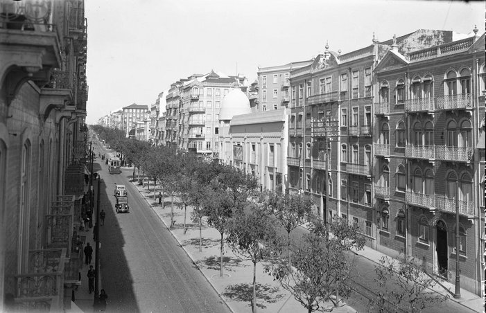
From the 1960s and 1970s onwards, there was a change in the vision of urban planning, based on the Haussmannian canons of city organization and expansion, with Frederico Ressano Garcia's modernist ideas standing out in this context.
As part of the general plan to renew the city's design, along with Avenida da Liberdade, the tree-lined luxury "Boulevard", and the Avenidas Novas Plan, Avenida dos Anjos (Avenida Rainha Dona Amélia, from 1903, and Avenida Almirante Reis, after the establishment of the Republic), emerged with an integrated plan of new subsidiary streets and real estate development in its adjacent areas, which extended as far as the Estrada da Circunvalação (military road, administrative and fiscal border of the city), at the intersection of the current Praça do Chile.
Due to the municipality's inability to manage the difficulties inherent in the process, private urbanization initiatives emerged to accompany the structuring plan, such as Bairro Açores, Bairro dos Castelinhos or Bairro Andrade, the latter built by a local landowner (naming the streets after the ladies in his family).

The Bairro das Colónias and the dismantling and reconstruction of the Igreja dos Anjos installed
Later, in the 1930s, the Bairro das Colónias (now the Bairro das Novas Nações) would be built in a low and swampy area, corresponding to the area known until then as "Charca".
In general, the Avenida dos Anjos project would take a long time to complete, due to the difficulties involved in expropriating land. Although the pre-existing buildings were respected, there were larger interventions, such as the dismantling and reconstruction of the Igreja dos Anjos, previously located on the narrow Rua do Anjos, in a new location on the new avenue. The constraints on traffic caused by pre-existing structures were not completely overcome, since it was only at the end of the 1920s that Rua da Palma was definitively widened.
Phase IV (1927-28) - Extension to Alameda Dom Afonso Henriques
A smaller, less regular urban grid with a less coherent design
The lack of definition and constraints in the various projects of the 1920s, in particular the urban design still strongly influenced by the 19th century, the planned installation of railway infrastructures in the area to the north-east, or the Arroios Market to the east, would result in a smaller, less regular urban network with a less coherent design, as can be seen in the divergence of Rua Guerra Junqueiro, which would later be integrated into the network of the final stretch of Almirante Reis.
Harmonize and articulate Avenidas Novas with Almirante Reis
The execution of this section of the avenue, which could only go ahead after the expropriation of the fence of the former Arroios Convent (then Arroios Hospital), had the initial objective of joining the new axis with the old Sacavém Road.
This plan, after the fall of the First Republic, sought to harmonize and articulate Avenidas Novas with Almirante Reis (here seen as an incorporating road for future plans) through an extended radial road to the eastern side of the latter, focusing on the symmetrical design of the surroundings of the Instituto Superior Técnico and Alameda.
Phase V (1938-1946) - Extension to Praça do Areeiro
Extended design of the remaining blocks of Bairro do Areeiro, with decompression pockets, such as Alameda and Praça João do Rio
Although this last section had already been sketched out since 1928, only the configuration of the Bairro dos Atores remains from that plan. Even with the usual constraints and pre-existences resulting from the previous plan, and above all the maintenance of the 25-meter width of the avenue, the extended design of the remaining blocks of the Areeiro Quarter, with decompression pockets such as Alameda and Praça João do Rio, plus the architectural coherence of the buildings, give this area a scenic and more bourgeois vision, distinct from the rest of the avenue to the south.

Creation of Areeiro Square
The creation of Praça do Areeiro would become a symbol of the urban remodeling operation in the city of Lisbon. This visual finishing touch to the road would define a landmark for those arriving in the city from the also recent Portela Airport. This space would have to be monumental and grandiose, in the same logic as the creation of the Alameda and the Luminous Fountain, making Areeiro a real entrance to Lisbon.